10 reported tornadoes in southern MN, Twin Cities deals with flash flooding
MINNEAPOLIS (FOX 9) - We had a wild Wednesday of Mother Nature, with severe storms racing across southern Minnesota, while the Twin Cities and areas west are dealing with flash flooding after heavy rain.

Floods disrupt Twin Cities evening commute Wednesday
FOX 9's Ian Leonard has the latest on severe weather impacting different parts of Minnesota.
Here's the latest on the weather in Minnesota:
10 reported tornadoes in southern MN
The backstory:
The National Weather Service issued Tornado Warnings throughout much of southern and southeastern Minnesota Wednesday afternoon as a line of storms rolled across Interstate 35 and into western Wisconsin. FOX 9 views captured what appears to be a tornado near Medford, a small town between Owatonna and Faribault.

Funnel cloud spotted near Medford
Severe weather is being reported across Minnesota with tornado warnings in effect in the southern part of the state.
There were 10 reported tornadoes in southern Minnesota Wednesday afternoon.
As of 7 p.m., there were no reports of significant damage from the National Weather Service related to the severe storms in southern Minnesota. The only damage report was a utility pole down near the post office in Hokah, located in Houston County.
Flash flooding in Minneapolis, Renville
What we know:
Heavy rainfall in the Twin Cities and areas west caused flooding in Minneapolis and in Renville. Near The Beach Club Residences on Bde Maka Ska, flash flooding trapped cars on the street. A few motorists in northeast Minneapolis got stranded and had to be towed when their vehicles got stuck and stalled in floodwaters.

Minneapolis flooding caused by heavy rain
Floods caused by heavy rain are leading to stalled vehicles and blocked roads. FOX 9's Mike Manzoni has the latest live from Minneapolis.
In Golden Valley, heavy rain caused flash flooding in the street and made roads impassable for a brief time.
In Renville, residents were asked to reduce their water usage on Wednesday after heavy rainfall caused flooding.

Renville streets flooded after heavy rain
Some streets in Renville are flooded following heavy rain. FOX 9's Leon Purvis has the latest report.
Renville flooding:
The City of Renville is asking residents to reduce water usage by taking the following steps:
- Do not take a shower or bath
- Do not wash dishes
- Do not do laundry
- Only flush the toilet when necessary
Residents are also told to make sure all sump pumps are discharging into lawns or streets and not into sanitary sewer drains.
Wednesday rain totals
Who got rain:
Roseville saw the heaviest rainfall in the Twin Cities with a total of 4.27 inches. Burnsville had the smallest amount of rain in the metro at 0.81 inches, barely more than the 0.78 inches seen in River Falls.
Minnetonka got more than three inches of rain, while several cities got two inches or more. Those include Maple Plain, Mound, Waconia, Victoria, Coon Rapids and Robbinsdale.
Here's a look at all the rain totals obtained by the FOX 9 weather team.
More showers Thursday, dry day Friday
What's next:
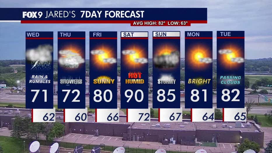
Thursday will feature periods of rain showers under mostly cloudy skies and highs in the low 70s.
Friday brings a break from the rain with more sunshine and warmer temperatures in the 80s. The weekend turns hot and humid, with highs in the low 90s on Saturday. There’s also a chance for scattered showers and storms on Sunday.
Heading into next week, calmer conditions return with highs holding in the 80s.
Here's a look at the seven-day forecast: