8 tornadoes reported in Minnesota, western Wisconsin during Thursday's storms

Thursday storms bring eight reported tornadoes
Strong and severe storms swept across Minnesota and Wisconsin Thursday afternoon, dropping as many as eight reported tornadoes.
MINNEAPOLIS (FOX 9) - As many as eight tornadoes touched down in Minnesota and western Wisconsin on Thursday as storms pushed east.
Storms begin to push into northern MN, Wisconsin
What we know:
The worst of the storms have passed out of the Twin Cities metro but tornado warnings have been issued in parts of northern Minnesota and western Wisconsin as the storms push east.

Footage of multiple tornadoes touching down in MN, WI
Tornadoes were reported in Minnesota and western Wisconsin on Thursday as storms pushed east. There was a report of an observed tornado in the New Richmond area and near Roberts around 3:30 p.m. There was also a report of a tornado near Spring Hill, not far from Melrose, that left behind debris.
There was a report of an observed tornado in the New Richmond area and near Roberts around 3:30 p.m.
Tornadoes reported north of Twin Cities
What we know:
The National Weather Service says a tornado was reported in central Minnesota near Melrose, Minn. – about 30 miles northwest of St. Cloud. The report came in at around 2:52 p.m.
There was also a report of a tornado near Spring Hill, not far from Melrose, that left behind debris.
The National Weather Service issued a tornado warning for parts of Stearns and Todd counties as a result of the report.
Tornado warning issued for downtown Minneapolis
What we know:
A doppler-indicated tornado warning was issued covering downtown Minneapolis at 2:25 p.m.
There are no reports of observed tornadoes or funnel clouds in Minneapolis.
Power outages have been reported in the Twin Cities as a tornado-warned storm moved through downtown Minneapolis. According to Xcel Energy Center's outage map, more than 2,500 customers have been impacted in the Twin Cities metro.
The warning expired at 2:46 p.m.
Tornado watch in MN, WI
Why you should care:
The tornado watch is in effect until 8 p.m. for much of central Minnesota and western Wisconsin.
The watch storms expected in the afternoon hours could bring a few tornadoes along with large hail and wind gusts up to 70 mph.
The storms are set to move through in the early to mid-afternoon hours. The watch expires at 8 p.m.

Funnel cloud in Benson, Minnesota
A funnel cloud was captured on camera during a tornado-warned storm in Benson, Minnesota, on May 15, 2025. This video was sent to FOX 9 by Tammy.
Tornadoes reported in western Minnesota
Local perspective:
The National Weather Service says a trained observer reported a tornado spinning southwest of Benson, Minn. in Swift County around 1:15 p.m.
That's about 120 miles west of the Twin Cities. FOX 9 is tracking the storms and will provide updates as available.
Minutes later, the weather service reported another tornado report southeast of Morris, which is just to the north of the other report.
Storm photos
What you can do:
If you are able to safely take a photo of the storm or of damage, you can send them to fox9.com/photos.
Timeline of what to expect with Thursday afternoon storms

Timeline:
The afternoon storms are forecast for the region between noon and 7 p.m. on Thursday.
Storms will start earlier in central and southern Minnesota, before moving to the north and east. The Twin Cities metro could see storms in the early afternoon hours before wrapping up around 3-4 p.m. The storms are forecast to move out of the FOX 9 viewing area by the dinner hour.
The area that could see the highest chance of severe weather is in western Wisconsin, stretching into the northern end of the I-35 corridor.
What to expect:
Afternoon storms could bring large hail that's 1-2 inches, wind gusts of up to 60-plus mph, and there is an isolated risk of tornadoes.
Parts of central Minnesota are also under a Level 2 and Level 3 risk of severe weather on Thursday. The Level 3 risk stretches from eastern Minnesota, including areas near and northeast of the Twin Cities, into Wisconsin.
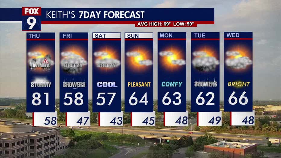
The high on Thursday is around 81 degrees in the Twin Cities metro.

The severe weather outlook for May 15, 2025.
Much cooler weekend
What's next:
After a stretch of sunny, warm weather this week, things are changing. Thursday will bring the potential for storms, and then it gets much cooler for the weekend.
Widespread 50s are in the forecast for Friday afternoon.
This weekend, highs in the 50s are in the forecast on Saturday, while Sunday will be more pleasant, with highs in the 60s and some sunshine.